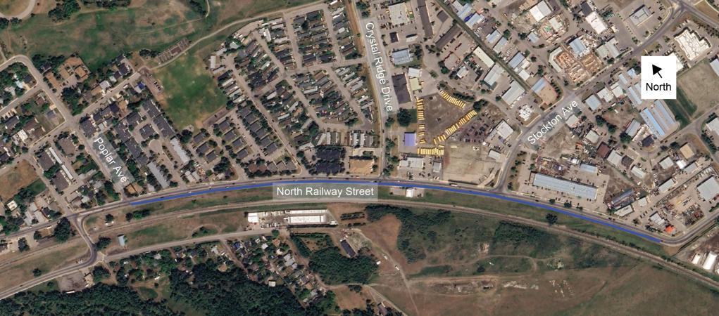
The Town of Okotoks is installing a protected two-way bike lane on North Railway Street between Poplar Avenue and west of 32 Street E. The project supports the Town's Active Transportation Implementation Plan and will improve safety, connectivity and access by creating an important link between existing pathway connections. The project is designed to make it safer and easier for people walking, rolling, cycling and driving to travel through the corridor.
Construction start: Week of August 24, 2026
Construction end: mid-October, 2026
Pavement markings for the bike lane are underway; however, the bike lane is not yet open for public use. We will publish an update when construction is complete and the bike lane is open and safe for public use. Until then, please avoid using the facility and continue to follow all posted traffic control measures.
More Information
The project includes:
- A protected two-way bike lane on the south side of North Railway Street
- Parking restrictions located throughout sections on the north side of the roadway
- Lane adjustments to accommodate all users safely
- New pavement markings, signage and barriers
This project improves safety and connectivity along a key east-west corridor and helps complete an important link in Okotoks' active transportation network. It supports safer travel options and improves access to downtown and surrounding areas.
What to Expect During Construction
- Temporary lane restrictions and traffic adjustments
- Vehicle access maintained throughout construction
- Temporary pedestrian and cycling detours, where required
- Short-term noise and construction activity
- Businesses remain open during construction
What is happening on North Railway Street?
The Town of Okotoks is installing a protected two-way bike lane on the south side of North Railway Street between Poplar Avenue and west of 32 Street east. The project will improve safety and connectivity by linking existing pathway infrastructure and completing an important connection in Okotoks' active transportation network.
Why is the Town building a bike lane here?
The project is a priority identified through the Town's Active Transportation Implementation Plan. North Railway Street serves as an important east-west corridor and the bike lane helps create safer travel options for people walking, rolling, cycling and driving while improving connections between existing pathways.
How long is the bike lane?
The protected bike lane runs along North Railway Street from Poplar Avenue to west of 32 Street east, which is just over 1 km.
Why not build the bike lane somewhere else?
North Railway Street was identified as a priority corridor because it fills a gap between existing pathway connections and improves access to downtown and surrounding areas. The project helps complete a key link in the active transportation network.
Will vehicle lanes be removed?
No. The design retains existing vehicle travel lanes in both directions throughout the corridor and adds separate left turn lanes at the two major intersections to formalize vehicle movements at those locations. The roadway was reallocated within the existing pavement width rather than removing a through traffic lane.
Why are vehicle lanes being narrowed?
The roadway is being reconfigured to create space for a protected bike lane while maintaining vehicle access. The narrower vehicle travel lanes also reflect the existing 40 km/h posted speed limit for this corridor .The design helps accommodate people driving, cycling, walking and rolling more safely within the existing road corridor.
Is this taking away parking?
Some parking restrictions have been introduced along sections of the north side of North Railway Street to accommodate the bike lane and roadway improvements. Parking is not being removed along the entire corridor.
How will the project affect nearby businesses?
Businesses will remain open during construction. Vehicle access to businesses will be maintained whenever possible, and the Town will work to minimize disruptions throughout the project.
Will emergency vehicles still be able to use North Railway Street?
Yes. The corridor will remain accessible and has been designed to continue serving all roadway users, including emergency services. Emergency services were identified as a key audience during project planning.
How will cyclists safely cross intersections and driveways?
The protected bike lane includes pavement markings, signage and barriers designed to improve visibility and safety for all users. At driveways, vehicles and bicycles travelling along North Railway Street have the right-of-way over vehicles accessing driveways along North Railway Street, exactly the same way they did before the bike lane was implemented. Cross-rides have been implemented at the Stockton Avenue and Crystal Ridge Drive intersections to allow cyclists to enter and exit the bike lane at those locations. Additional educational content and signage will be provided following project completion.
What is a cross-ride?
A cross-ride is the cycling equivalent of a pedestrian crosswalk. It is a designated location where cyclists are expected to cross a roadway, typically where an on-street bike lane, multi-use pathway, or shared-use path intersects with a road. Cross-rides are commonly identified by:
- "Elephant's feet" pavement markings (pairs of white squares)
- Bicycle crossing signs
- Associated traffic control signage and markings
- Connections to bicycle lanes or pathways on either side of the roadway
The purpose of a cross-ride is to provide a predictable location for cyclists to cross and to alert motorists that bicycle traffic may be present. Additional educational content and signage will be provided following project completion.
How do cross-rides work?
Cross-rides function similarly to pedestrian crosswalks in that they identify a designated crossing point for active transportation users. The markings and signs are intended to clearly communicate where crossings are expected to occur and to improve visibility between motorists and cyclists. At a cross-ride, cyclists should:
- Approach the crossing at a controlled speed.
- Ensure they are crossing in accordance with any traffic control devices.
- Watch for vehicles that may be turning through the crossing.
- Proceed only when it is safe to do so.
- Make reasonable efforts to ensure drivers have seen them before entering the crossing.
Motorists should:
- Be alert for cyclists approaching or using the cross-ride.
- Watch for bicycle traffic when making turns across bicycle lanes or crossings.
- Obey all traffic control devices and signage.
- Yield to cyclists where required by the signage and traffic controls at the crossing location.
Additional educational content and signage will be provided following project completion.
What does "protected" bike lane mean?
A protected bike lane is physically separated from vehicle traffic using barriers and other roadway elements. The North Railway Street project includes delineators, signage and pavement markings to help create separation between cyclists and motor vehicles.
Will pedestrians still be able to access the area?
Yes. Pedestrians expected to continue using the sidewalk along the north side of North Railway Street by crossing at the locations indicated by signage at Poplar Avenue on the west and Fisher Gate to the east.
How long will construction take?
Construction is underway and expected to last until the end of September, weather permitting.
What impacts should I expect during construction?
Residents, businesses and roadway users may experience:
- Temporary lane restrictions
- Traffic adjustments
- Some parking restrictions
- Temporary pedestrian and cycling detours
- Construction noise and equipment activity
The Town will work to maintain safe access and minimize disruptions wherever possible.
Will taxpayers be paying for this project?
Yes. Like other transportation infrastructure projects, the bike lane is a municipal infrastructure investment that supports transportation safety, accessibility and network connectivity for the community. The project is part of the Town's implementation of its approved Active Transportation Plan.
Is there enough demand for a bike lane in Okotoks?
The project was identified through the Town's Active Transportation Implementation Plan and supports a broader community network that serves people of all ages and abilities who choose to walk, roll or cycle for recreation, commuting and everyday trips. Public engagement completed as part of that planning process identified a desire for safer and more connected cycling facilities, particularly along key corridors that connect residential areas, schools, recreational amenities and commercial destinations including North Railway Street.
How does this benefit people who don't cycle?
The project is designed to improve safety and connectivity for all users. Benefits include improved roadway organization, clearer travel movements, enhanced pathway connections and additional transportation options within the community.
Will the bike lane be cleared in the winter?
Yes. The bike lane will be maintained as part of the Town's transportation network. Snow and ice control will be completed as operationally feasible, similar to other transportation infrastructure throughout the community. While clearing activities may occur at different times depending on weather conditions, available resources and operational priorities, the Town intends for the bike lane to remain a year-round transportation option. The protected design has been developed with ongoing maintenance considerations in mind.
Project updates, schedules and construction information will be available at www.okotoks.ca/construction throughout the work.